Saturday, June 30, 2007

Vancouver, BC

This is a great city! We've been through here three times and during one of those, spent a few days (prior to an Alaskan cruise) with Lillie and Mom. Always wanted to return. This was the last stop in Canada during our venture north this year.

There's only one campground (that I could find) that was even close to the city. Capilano RV Park is really close to downtown (easy 10 minutes). In the first picture, you see what almost looks like a large, wooded, island. That land is literally connected to downtown Vancouver and is called Stanley Park—a 1,000-acre park—i.e., huge.


Follow the bridge from Stanley Park toward where I am standing and that's where Capilano RV Park is located—under the north end of the bridge. A bit pricey at $44.00 CN per night but definitely saves you tons of driving time around the city. It was worth it.

Vancouver is a great restaurant city—my kind of town. We had Hungarian food (cabbage rolls), Ukranian food (sausages and veal), and Chinese food (Peking duck). Vancouver has the second largest Chinese population in North America.

Just north of the campground was one of the famous sites in the area—the Capilano Suspension Bridge. It's real and it's shaky but worth the effort.


After crossing the bridge, you are in a rainforest that has been (pretty well) preserved. The unusual thing is that they have constructed walkways up in and through the trees. It's a very different perspective from 50-feet up. These did not shake and were very well done. It was an easy climb.


Driving a bit farther north from the Suspension bridge, you end up at Grouse Mountain. This mountain literally drops into this part of North Vancouver, is a ski run, and tourist destination. We took the tram up. You can walk around the top. I was on top Grouse Mountain when I took the picture of the city (the first shot above).

One thing to see was the lumberjack show. With log rolling, axe throwing, and pole climbing, it was a fun show (all included in the one ticket price).


An unusual feature on Grouse Mountain were the woodcarvings. These were huge, excellent, and a lot of them. Here's just one to give you an idea. All of them are about the same size—this one is about 18-feet tall and 4-feet in diameter—just huge. The detail is spectacular.

Jasper National Park and Southwest

Driving from the Ice Fields north to Jasper, we passed through some great country. The mountains are a bit less rugged up here but continue to be majestic.


Waterfalls everywhere!


There's lots of wildlife, too.


We paid for our most expensive boondocking site (no hookups) just outside of the town of Jasper. It was in Whistler Campground (run by the Canadian Parks) and the cost was $25.75 per night. That's expensive parking but it's the only option.

Jasper (town) is small and we didn't find much to do there. Lots of trails and ski areas but not for us. So we left. We headed west out of the Park and then turned south. Our ultimate goal now is Vancouver but no hurry.

We found a campground (one that actually had 50-amp) in Valemount, BC and stopped there. This was really a one-horse tiny town with 3-4 tourist motels. We were driving around and found that they were full of Japanese tourists.

The good news... The "Caribou Grill"—a really nice steak house. But, the
Really Good News is that they specialized in Caribou steaks. We had been looking to try these all the way through the park. Finally! They were great!!! They were even better than the Muskox stew I had in Jasper.

A Piece of the Rock

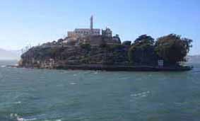
“Alcatraz rocks!“ was the comment from one of the children on our tour boat. We were headed to Alcatraz—the former federal prison and now national park—for a tour of the facility and island. The boat ride is the only way to get there. We departed from the San Francisco wharf next to the infamous Pier 39—itself, a major tourist destination. Alcatraz was made a part of the Golden Gate National Recreational Area in 1972. The National Park Service (NPS) operates the facility.

Infamously known as “The Rock,“ Alcatraz was the ultimate destination for prisoners deemed incorrigible or a troublemaker. A few prisoners whose names you may recognize include Al Capone, Alvin Karpis, George “Machine Gun“ Kelly, and Robert Stroud, the “Birdman of Alcatraz.“

After stepping off the boat, the walking tour of Alcatraz is at your own pace. Numerous departure times for the return boat are posted so you can stay on the island as long as you want. There is a steep walk (12% grade) up to the main Cellhouse building and a tram is available for those unable to make the climb.

An audio tour is the recommended way to hear the information. You get a comfortable set of earphones and a simple-to-operate player that allows you to stop the narrative at any time, replay when needed, and there are clear directions pointing you to the next point of interest. The information is excellent and the stories and comments by former prisoners are interesting.

Alcatraz was a real prison specially designed to hold some of the toughest and meanest prisoners this nation had incarcerated at that time. The tour walks you through the cell blocks where you have a close-up view of the real cells where prisoners lived.


During the tour, viewing the individual cells, “segregation,“ and “isolation“ is an eye-opening experience. Rule Number 5, Alcatraz Prison Rules and Regulations, 1934, stated that, “You are entitled to food, clothing, shelter, and medical attention. Anything else you get is a privilege.“

When a prisoner was placed in “segregation,“ it was not considered additional punishment. This move was designed to simply separate prisoners and prevent contact. Interestingly, the “segregation “ cell is actually larger than the normal cell.

Special cells called “Isolation“ were designed for the highest level of punishment. Inmates referred to the isolation cells as the “Hole.“ When the outer door to the cell was closed, the interior of the cell was in total darkness. Listening to the audio tour, one prisoner described his time in isolation as follows…
"He stated that to pass the time and keep from going crazy, he would rip a button off his clothes, then flip that button up in the air, he would turn around three times, and then search the floor for the button—by feel—by crawling around. Simply, it gave him something he could do in total darkness."


Prisoners were kept in the isolation cell 23 hours per day. This punishment was, in effect, the total loss of all privileges.
Visitation with the immediate family was also a privilege (remember Rule #5) and, as with all activities (privileges), was regulated by a set of rigid rules. These visitation rules were designed to control the visitation and prevent potential problems. The inmate and his visitor were separated by a window of thick glass and conversation was by phone. All conversations were monitored.

Occasionally, prisoners would be able to see across the bay. There, San Francisco beckoned them. One Alcatraz myth is that it is impossible to survive the swim to the mainland because of sharks. However, there are no “man-eating” sharks in San Francisco Bay. The cold water (averaging 50–55 degrees), strong currents, and 1-1/4 miles to shore were excellent deterrents.


In 1934, prior opening Alcztraz, a teenage girl swam to the island to prove it was possible. The fitness guru Jack LaLanne once swam to the island pulling a rowboat, and two 10-year-old children also made the swim.

Thirty-six men (two who tried twice) were involved in fourteen escape attempts from 1934–1963. Twenty-three were caught, six shot and killed, and two drowned. Officially, no prisoners succeeded in escaping from Alcatraz, however, five prisoners are listed as “missing and presumed drowned.“

Frank Morris, with John and Clarence Anglin (brothers ) escaped from their cells and never seen again. Another inmate, Allen West, believed to have been the mastermind, was involved but was still in his cell the next morning after the escape. “Escape from Alcatraz,” the movie starring Clint Eastwood as Frank Morris, was the story of this escape. The men used prison-issue raincoats to make crude life vests and a pontoon-type raft to help them survive the swim. The three men were never found.

Friday, June 29, 2007

Columbia Ice Fields, Banff/Jasper, Alberta

Banff and Jasper National Parks border each other. As you travel (north or south), you cross from one to the other. The middle is the Columbia Ice Fields—a huge area of glaciers (and ice fields). These ice fields provide much of the water to western North America including the Columbia River. That's a lot of water!


The major experience there is to tour one of the glaciers by riding on the Ice Explorer—a special vehicle designed to travel on the ice.


The glacier is, of course, huge and spectacular. The Ice Explorers have a designated route to follow and (in theory) they are not detrimental to the glacier itself. It does seem that the Canadians are taking special care of the environment.


This shot is actually taken from across the highway—at the Visitor's Center. Even with a telephoto, you can barely see the Ice Explorers making their way back down from the glacier. Those two black dots are the Ice Explorers.


Cold, it was! (I sound like Yoda now.) That wind starts someplace in the Pacific Ocean, makes it across British Columbia, and whips over and down on top of this glacier. I have no idea what the windchill was standing here.


There is a nice visitor center there but not much else. The large parking areas can hold about any size crowd. It was not crowded but we were there before the major tourist influx. Notice our coach in the far right parking lot. This lot is designated for overnight parking, too. Fill out the form, put your $9.90 in the envelope, and you are good for the night. There are no hookups or dumps here. Just a place to park overnight. The evening lights were fantastic. Quiet, too.


Here's another look at the Visitor's Center from the glacier. That's our coach in the lot to the left—looking lonely.

Monday, June 25, 2007

Canadian Rockies

Western Canada
Empty! That’s what this country is. Wow! After touring the Tunnels in Moose Jaw, SK, we drove to Swift Current, SK today—about 100 miles. This is the area where they grow the wheat and when you have seen pictures of the huge number of combines on those wheat fields, well, we drove through a bunch of those fields today. The combines aren’t there now. This is, without question, the flattest country I’ve ever been in. Miles without so much as a hump in the road. Laid out T-square straight. Reminds me of the movie years ago entitled “Amber Waves” (Dennis Weaver)—worth seeing.

By the way, they call Moose Jaw the “Buckle on the Wheat Belt”—appropriate.

Here’s some proof—unretouched!


Frank Slide
West from Lethbridge, AB, we drive across Crowsnest Pass. There, in 1903, "Frank Slide," the greatest landslide in North American history wiped out the town of Frank in 100 seconds! It literally could not be cleaned up and it quite spectacular to visit. You can see some of the result of the whole side of the mountain sliding down. Sandy is standing in the debris field.


Fort Steele
We stayed south of the Park for a few days not knowing how primitive the area was we were headed into. We shouldn't have been concerned—everything was fine in the Park—not primitive at all and only had two nights where we boondocked.

However, the campground at Fort Steele was a pleasant surprise. Take a look at these views...


Banff National Park
I’m sitting here at the table, facing forward, writing this. It’s raining gently. About 30-40 yards out front (kind of open-woodsy), four elk are playing (1 bull, 2 cows, and—I think—one calf). Fascinating! Can’t get a picture of them as it will focus on the sunshade material on our windshield. Continue to see LOTs of wildlife—deer and elk literally walking the side streets in town. Sandy saw two grizzlys yesterday as we were driving. Plus, we have seen several black bears, big horn sheep, mountain goats, and even one grey wolf!

Visited Lake Louise yesterday—REALLY COLD!!! Wind coming down off that glacier and across the lake was hitting us in the face. Gorgeous area but cold.


Still plenty of snow here! This was from the cleared parking lot.


Driving back, we are on a one-lane (passing through a former landslide area) and up popped these sheep. The lamb could not make it over the barrier in one hop so would perch on top and then hop down. He went back and forth a couple of times. There is eight sheep in this herd.


This continues to be one of the most spectacular campsites we were ever in!!!


Another view...


Temperature hovers around 50 degrees (except near the lake) and rain every day—not much but consistent. They had nearly record snows here this winter. They have had record rains lately. The rains causes a faster snow melt so the rivers are maximum. They all are grey/green with glacier silt and fast moving.


It’s time to move on and we are headed into the first “wild” area tomorrow—the Columbia Ice fields (find it on Google). There are two “campgrounds” there with no hookups, period. We were told there may not even be a restaurant—that’s really roughing it! Then on north into Jasper but was told not to plan on any towns there either. We shall see.

Saturday, June 23, 2007

Milestone in My Life


I definitely passed through another milestone in my life today. Here's the proof...